A large winter storm is continuing to batter wide swaths of the U.S., with alerts stretching from the Northeast through the Rockies — and significant impacts across Alaska. Forecasters say some locations could see up to 18 inches of snow, along with strong winds and periods of mixed precipitation that may create slick roads, low visibility, and dangerous travel into early next week.
Most warnings remain in effect through late Saturday, though some alerts — especially in Alaska — extend into Monday. Officials also caution that the combination of wind, ice, and heavy snow could lead to scattered power outages in the hardest-hit areas.
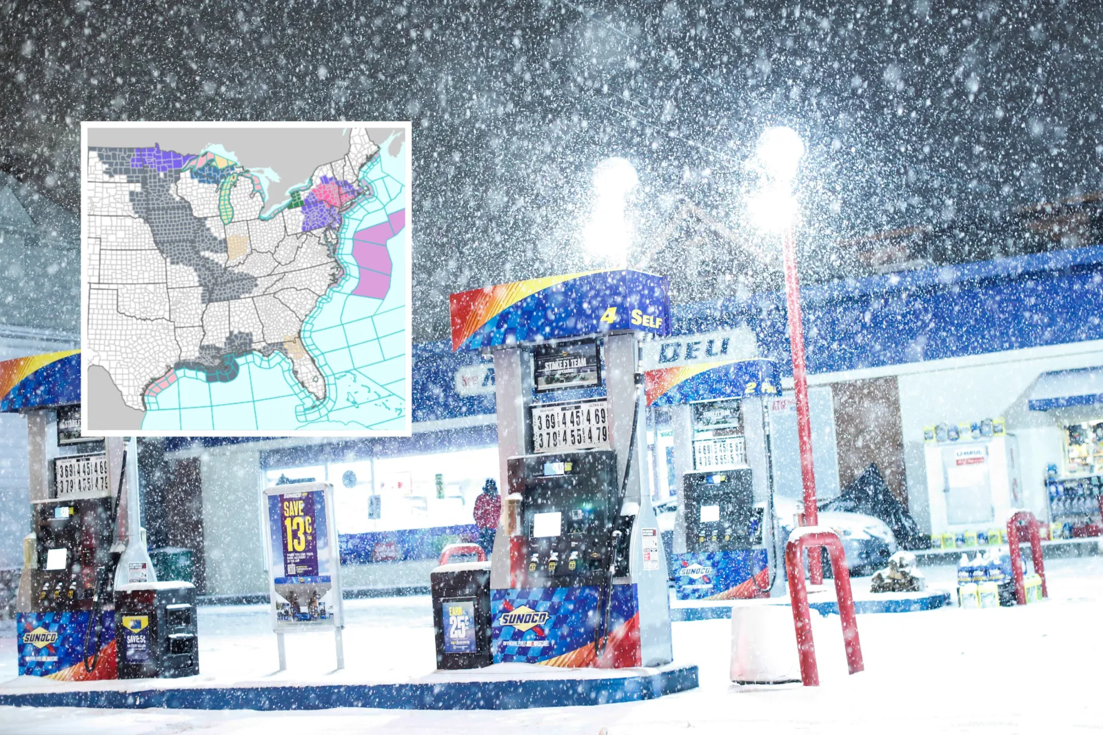
Winter Storm Warnings
The National Weather Service (NWS) has issued winter storm warnings impacting at least 10 states as the system pushes across multiple regions.
Northeast
Connecticut
Hartford County remains under a warning until 10 a.m. Saturday, with up to 1 inch of additional snow possible. Middlesex, New London, Fairfield, New Haven, and Litchfield counties are expected to see heavy snow or mixed precipitation into early afternoon, with up to 2 inches of snow and a light glaze of ice. Road conditions are expected to be hazardous, with visibility potentially dropping below a quarter mile. The NWS warns that roads — especially bridges and overpasses — may become slick and dangerous.
Massachusetts
Western Hampden County is under a warning until 10 a.m., while the Berkshires may pick up up to 2 inches of snow through early afternoon. Travel conditions may be risky until the snow tapers to lighter activity later in the day.
New York
Warnings cover the Capital Region, Mohawk Valley, Catskills, and Taconics until early afternoon, with up to 2 inches of snow. Central and southern counties — including Oneida, Onondaga, and Sullivan — could see 6–12 inches before snow ends by daybreak. Long Island and New York City boroughs remain under warnings until 1 p.m., with light snow and ice contributing to treacherous travel.
New Jersey
Eastern Passaic, Hudson, Essex, and Union counties may see heavy mixed precipitation through early afternoon, increasing the risk of icy patches and slick roads.
Pennsylvania
Northern Wayne and Pike counties remain under warnings until 7 a.m., with snow, sleet, and light ice accumulation. The NWS advises travelers to keep emergency supplies — such as a flashlight, food, and water — in their vehicle if they must drive.
Rockies and West
Colorado
Rabbit Ears Pass and the Elkhead and Park Mountains could see 6–18 inches of snow with gusts up to 45 mph through early Sunday. Wolf Creek and Cumbres Pass may receive 6–12 inches, with winds near 50 mph, making conditions especially dangerous on higher-elevation routes.
Idaho
Mountain regions including the Sawtooth Basin and Sun Valley are forecast to get 8–18 inches of snow through Saturday. Gusty winds could create blowing snow and sharply reduced visibility. The NWS recommends checking road conditions via 5 1 1 or 511.idaho.gov.
Wyoming
The Sierra Madre Range may see 12–18 inches of snow with winds up to 45 mph through Sunday morning. Officials warn that outdoor recreation could become life-threatening as conditions deteriorate.
California
Mono County remains under a warning until early Saturday, with up to 18 inches of snow possible at higher elevations. Wind gusts may exceed 80 mph along ridgelines, increasing the risk of blowing snow and near-whiteout conditions.
Alaska
Alaska’s Panhandle is expected to see some of the storm’s most extreme totals. Yakutat could receive up to 45 inches of snow, while Juneau may see up to 34 inches through Monday. Skagway and Haines could pick up 18–36 inches, and other areas — including Admiralty Island and Annette Island — may see 5–9 inches. Strong winds and blowing snow may make travel nearly impossible, and some locations could see rain or freezing rain mixing in late in the weekend.
Key Impacts
Travel may be hazardous — or impossible — in parts of the affected regions due to blowing snow, icy roads, and poor visibility. Most warnings outside Alaska are expected to end Saturday morning or afternoon, while Alaska’s alerts extend into Monday.
Winter Weather Advisories
Winter weather advisories remain in effect across the Rockies, the Pacific Northwest, Alaska, and parts of the Northeast and Mid-Atlantic. These advisories highlight ongoing threats from snow, ice, and strong winds that may significantly affect travel.
Most advisories expire Saturday morning or evening, though some extend into Sunday. Drivers should expect slick roads, areas of blowing snow, and reduced visibility.
Rockies and Intermountain West
Montana
Advisories cover the Beartooth and Red Lodge Foothills, Southern Big Horn, and Rocky Mountain Front, with 1–6 inches of snow and gusts up to 50 mph. Conditions are expected to worsen behind a strong cold front, creating rapid freeze-up and hazardous driving into Saturday afternoon.
Wyoming
The Snowy Range and nearby foothills could see 2–12 inches of snow with winds up to 55 mph through Saturday night. The Tetons and Wind River Range may pick up 8–14 inches, making mountain passes especially dangerous.
Idaho
The Caribou Range and Lemhi regions could receive 4–10 inches with gusts up to 45 mph through Saturday evening. The Northern Clearwater Mountains and Lookout Pass may see totals up to 16 inches, with blowing snow reducing visibility.
Colorado
The San Juan Mountains and central ranges are forecast for 4–12 inches through Sunday morning. The Sangre de Cristo Mountains may see 5–8 inches with gusts near 60 mph, increasing travel risks for holiday traffic.
Utah
The Wasatch and Uinta Mountains remain under advisories through early Sunday. Totals of 6–12 inches are expected, with up to 2 feet possible at the highest elevations. Southern ranges could see 6–12 inches by Saturday evening.
Pacific Northwest
Oregon and Washington
The Cascades and Blue Mountains are expected to see 4–11 inches of snow, with gusts up to 50 mph through Saturday morning. Mountain passes may become slick and visibility poor, especially during heavier bursts of snow.
Alaska
Advisories extend across the Kenai Peninsula and Alaska Peninsula, where 4–11 inches of snow and winds up to 65 mph could create whiteout conditions through Saturday evening. Sitka and nearby islands may see 4–9 inches before precipitation transitions to rain late Saturday.
Southwest
Arizona
The Kaibab Plateau could see 2–4 inches of snow above 7,000 feet through Saturday evening, creating slick and hazardous driving conditions.
New Mexico
The Sangre de Cristo and Tusas Mountains may receive 1–12 inches of snow through Sunday morning, with gusts up to 45 mph. Travel could be difficult on higher-elevation routes.
Northeast and Mid-Atlantic
New England
Massachusetts, Rhode Island, and Connecticut remain under advisories until mid-morning Saturday, with light snow causing slippery roads. Cheshire County, New Hampshire, could see up to 2 inches.
New York and Pennsylvania
Southern Tier counties may experience mixed precipitation with light snow and ice into early Saturday. Western New York could see freezing drizzle and snow, while Jefferson and Lewis counties may receive 4–7 inches.
Mid-Atlantic
Parts of New Jersey, Delaware, Maryland, and eastern Pennsylvania are reporting freezing drizzle and light ice through Saturday morning, making roads and sidewalks treacherous.
Advisory Impacts
Hazardous travel is expected to continue in many areas due to slick roads, blowing snow, and reduced visibility. Strong winds may also bring down tree limbs and trigger isolated power outages. Most advisories end Saturday, though some mountain regions remain under alerts into Sunday.