Name: Babylonian Map of the World (Latin: Imago Mundi)
What It Is:
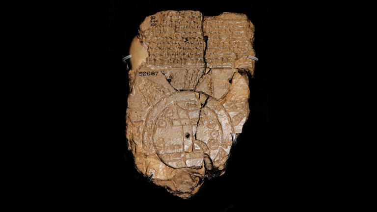
A clay tablet bearing the oldest known map of the world as imagined by ancient Babylonian civilization.
Origin:
Discovered in Abu Habba (ancient Sippar), located in present-day Iraq.
Date:
Created around the 6th century B.C.
What It Reveals About the Ancient World:
This small yet significant tablet offers a rare glimpse into how Babylonians viewed their world more than 2,500 years ago. The map shows the world as a flat disc, encircled by a ring of water labeled the Bitter River. At its center is the Euphrates River, with the city of Babylon prominently marked—though interestingly, only on one side of the river, despite the city historically spanning both banks.
Locations are labeled using cuneiform script, an early writing system developed in Mesopotamia.
Above the map, a block of cuneiform text describes how the god Marduk, the chief deity in Babylonian mythology, created the world. It names over a dozen animals—including lions, leopards, wolves, hyenas, and mountain goats—as well as legendary rulers like Utnapishtim, a figure said to have survived a great flood (a story similar to that of Noah).
On the reverse side, the tablet includes descriptions of eight distant regions, referred to as nagu, each with its own brief account.
Size:
The tablet measures just 4.8 inches tall by 3.2 inches wide (12.2 by 8.2 cm).
Where It Is Now:
This ancient artifact is part of the permanent collection at The British Museum.