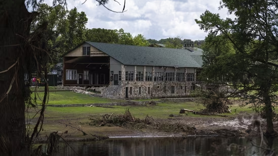
More than a decade before catastrophic flooding killed 27 people at Camp Mystic in Central Texas, the Christian girls’ camp had successfully petitioned the Federal Emergency Management Agency (FEMA) to exclude several of its riverside buildings from the official flood zone, according to federal records.
In 2013, FEMA granted an appeal from Camp Mystic to remove 15 buildings near the Guadalupe River from what’s known as a Special Flood Hazard Area—the designation for regions at risk of a 100-year flood, or an event with a 1% chance of occurring in any given year.
Although FEMA’s own documents indicated that some of those buildings sat just a few feet above the projected flood line—and at least one structure was below it—the exemption meant the camp was no longer required to carry federal flood insurance for those buildings. Other parts of the property remained within the flood zone and subject to related regulations.
Camp Filed Additional Appeals in 2019 and 2020
As the camp expanded, it filed two more appeals in 2019 and 2020, successfully removing another 15 buildings from FEMA’s flood zone maps. These appeals, first reported by the Associated Press, have drawn renewed scrutiny following the July 4 flooding disaster that left at least 129 people dead across the region. In Hunt, Texas, the Guadalupe River surged nearly 30 feet in just four hours, catching many residents and campers off guard.
At Camp Mystic, floodwaters surged into cabins just after sunrise. Campers and staff scrambled through waist-high water, many without shoes, to escape.
Political science professor Sarah Pralle of Syracuse University, who studies FEMA’s flood mapping process, criticized the repeated appeals. “It’s not just disappointing—it’s disturbing,” she said. “In a place caring for children, you’d think they’d err on the side of caution.”
Camp Mystic spokesman Jeff Carr confirmed via email that the camp had filed the appeals and that FEMA approved them. “Just as 90% of such appeals are approved by FEMA,” he noted.
Why the Appeals Matter
Experts say appeals to FEMA’s flood maps have become increasingly common, often motivated by property owners trying to avoid the costs of flood insurance or development restrictions. But with climate change intensifying storms and rainfall, some argue that removing properties from flood zones is a dangerous gamble.
“There’s just a lot of places that aren’t taking these risks seriously,” said Pralle. “We’re shrinking FEMA’s maps and removing properties, and that’s simply the wrong direction.”
FEMA defended its process, saying, “Flood maps are snapshots in time designed to show minimum standards for floodplain management and areas of highest risk for insurance purposes.”
Climate Models Show Higher Risk
However, independent assessments have painted a grimmer picture. According to First Street Foundation, a private firm specializing in climate risk modeling, Camp Mystic sits in a broader high-risk flood area than FEMA’s maps suggest. Their model includes variables like extreme rainfall, which FEMA’s standard flood maps often overlook.
“That area actually has one of the highest flood indices in the entire country,” said Jeremy Porter, head of climate research at First Street. On Sunday, flooding again hit the region, briefly halting recovery efforts for those still missing.
Porter said that rather than focusing on removing buildings from risk zones, Camp Mystic’s leadership would have been better served by preparing the camp for inevitable flooding events.
As Texas confronts more frequent and intense floods, the Camp Mystic tragedy raises broader questions about whether FEMA’s flood maps—and the appeals process—are adequately protecting the public.