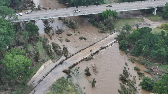
A devastating flash flood tore through the Texas Hill Country early Independence Day morning, claiming the lives of at least 68 people in Kerr County and leaving 10 girls from a summer camp still missing as of Saturday afternoon, July 6. More than a dozen additional fatalities were reported in neighboring counties.
The flooding unfolded rapidly as intense rainfall sent torrents of water cascading off hillsides into small creeks, which then overflowed into the Guadalupe River. A river gauge near the town of Hunt recorded a dramatic surge: the water level rose more than 20 feet between 3:00 a.m. and 4:30 a.m., climbing at a rate of nearly one foot every five minutes, according to National Weather Service data.
The region—renowned for its scenic beauty, rolling hills, and winding rivers—is also one of the deadliest in the country for flash flooding. Known as “Flash Flood Alley,” this area stretches from near Dallas to San Antonio and westward, and is uniquely prone to such disasters.
Why Hill Country Is So Dangerous in Floods
Texas leads the nation in flood-related deaths. From 1959 to 2019, over 1,000 people died in floods across the state—hundreds more than in any other U.S. state. A large share of those deaths occurred in the Hill Country.
Flooding is worsened by the area’s steep terrain and semi-arid soil, which doesn’t absorb water well. During storms, water runs off the hills rapidly, causing creeks to swell. When these creeks merge into rivers like the Guadalupe, the surge can become violent—washing away cars, homes, and people in seconds.
This isn’t the region’s first deadly flood. In 1987, a similar flash flood in western Kerr County killed 10 teenagers trying to escape a camp. Just weeks before the July 4 disaster, a flash flood in San Antonio on June 12 swept vehicles off roads near an interstate, killing 13 people.

What Triggers These Powerful Storms?
One major contributing factor is the Balcones Escarpment, a dramatic line of cliffs and steep hills formed by a fault line. As warm, moisture-laden air from the Gulf of Mexico moves inland and hits the escarpment, it is forced upward, condensing and dumping heavy rain over the hills.
As climate change drives global temperatures higher, the atmosphere can hold and release more moisture, making downpours more intense and increasing flood risk.
San Antonio, sitting at the eastern edge of Hill Country, is also vulnerable. Its extensive paved areas and aging drainage infrastructure can’t keep up with rapid runoff during storms, making flash floods more dangerous in urban zones.
What Can Be Done to Reduce the Risk?
Experts say education and forecasting are key to reducing flash flood deaths:
- Public awareness: Many flood deaths occur when people underestimate how quickly water can rise. In arid regions, even dry creek beds can become deadly in minutes.
- Improved forecasting: Using probabilistic models that simulate different rainfall and runoff scenarios could help local officials prepare for worst-case events and issue more effective warnings.
- Driver education: A shockingly high 58% of Texas flood deaths over the past 60 years involved vehicles. Just 12–24 inches of moving water is enough to carry a car away—yet many drivers still risk it.
- Better barriers: Officials can install more road barricades and closures during high-risk periods to keep drivers out of danger zones.
In the aftermath of yet another catastrophic flash flood, Hill Country residents and authorities alike are being reminded of the region’s dual identity: breathtakingly beautiful and brutally dangerous when storms strike.