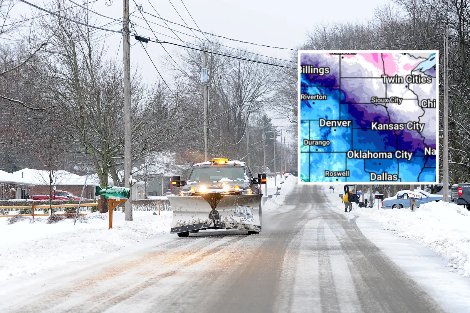
Millions of people across the United States are bracing for dangerous winter weather as a powerful storm sweeps from the Rockies to the mid-Atlantic, with the National Weather Service (NWS) warning that some locations could see up to 30 inches of snow.
Winter storm warnings, winter storm watches, and winter weather advisories stretch across at least 19 states and Washington, D.C., covering areas from the Rockies through the Midwest and Great Lakes to the Northeast and mid-Atlantic.
Officials are urging caution, warning of avalanche risks in mountainous regions and serious disruptions to travel and daily routines due to snow, ice, and blowing winds.
Winter Storm Warnings
According to the NWS, a winter storm warning is issued when forecasters are confident that heavy snow, sleet, or freezing rain will create major impacts, including hazardous travel and possible power outages.
The following states are under winter storm warnings:
Alaska
In northwest Alaska (including the Noatak and Kobuk Valleys and the western Brooks Range), a winter storm warning remains in effect until late Friday morning AKST. An additional 2–3 inches of snow, combined with wind gusts up to 40 mph, is producing whiteout conditions. Travel is described as “treacherous and potentially life-threatening” until the storm begins to weaken by mid-day Friday.
Kentucky
Central and northern Kentucky, including areas around Louisville and Lexington, experienced heavy overnight snow under winter storm warnings that continue until 10 a.m. EST Friday. Storm totals of about 3–5 inches are making roads slick and snow-covered, complicating the Friday morning commute.
The NWS advised: “If you must travel, keep an extra flashlight, food, and water in your vehicle in case of an emergency.” The warning is expected to expire by mid-morning as snowfall decreases. Eastern Kentucky (including Bath and Montgomery counties) also had a warning in place until 10 a.m. for an additional 1–2 inches of early Friday snow.
Indiana
Parts of southeastern Indiana are under a winter storm warning through Friday morning. Overnight, 3–5 inches of snow accumulated, leaving many roads snow-packed and hazardous for the morning drive. Conditions should gradually improve once the snow ends late Friday morning.
Montana
Much of Montana is under winter storm warnings as a significant snow event continues.
- Central and southern Montana (including Golden Valley, Wheatland, Musselshell, Yellowstone counties, and nearby areas) are expecting 4–7 more inches of snow through Friday evening, on top of earlier accumulations. Wind gusts up to 35 mph will further reduce visibility, making travel very difficult, especially during the Friday evening commute.
- Southeastern Montana (Stillwater, Big Horn, Rosebud counties and surrounding areas) remains under a warning until Friday night, with another 3–6 inches of snow expected by this evening. Roads are likely to become snow-packed with areas of very poor visibility.
- Northeastern Montana (Phillips, Valley, McCone, and nearby counties) is under a winter storm warning through early Saturday (until 8 a.m.), with 5–11 inches of snow forecast by the time the system exits. Slick and snow-covered roads will make travel dangerous through Friday night.
In the mountains, conditions are even more intense. The Crazy Mountains and Little Belt Mountains are on track to receive 8–16 inches of snow, with some localized totals up to 20 inches by Friday evening. Authorities caution that avalanche danger may increase in the backcountry as heavy snow piles up. High-elevation recreation will be affected until the snowpack stabilizes. Mountain winds are gusting up to 45 mph, causing blowing and drifting snow.
Winter Storm Watches
A winter storm watch is issued when there is moderate confidence that dangerous winter conditions — such as heavy snow, sleet, or freezing rain — may develop and significantly disrupt normal activities.
The following states are currently under winter storm watches:
Alaska
In the southern Panhandle (including Petersburg, Wrangell, and Prince of Wales Island), 6–12 inches of snow is possible from Saturday into Sunday, with some areas seeing a mix of snow and rain. Hyder could receive 20–30 inches of snow through Monday. Travel may become extremely difficult, and non-essential travel is discouraged.
Maryland
Far western Maryland, particularly Garrett County, is under a winter storm watch from Saturday afternoon through Sunday. This mountainous region could see 3–7 inches of snow. Mountain passes may become difficult to traverse due to snow-covered roads and low visibility. Wind gusts up to 35 mph could lead to blowing and drifting snow.
New York
Areas downwind of the Great Lakes — including Chautauqua, Cattaraugus, and southern Erie counties — could see 7 inches or more of lake-effect snow between Saturday and Sunday. Blowing snow and periodic whiteout conditions may severely disrupt travel.
Ohio
Parts of southwest Ohio (including Cincinnati and Wilmington) and northeast Ohio (including Lake, Ashtabula, and Cuyahoga counties) are under a watch for Saturday–Sunday. Snow totals of 3–6 inches or more are possible, boosted in some spots by lake-effect bands and gusty winds.
Pennsylvania
Erie and Crawford counties may receive 6 inches or more of lake-effect snow from Saturday into Sunday. Drivers should expect poor visibility, slick roads, and rapidly changing conditions.
West Virginia
Much of West Virginia is under a winter storm watch from Saturday through Sunday. Central and northwestern areas could see 4–8 inches of snow, while the higher elevations in the eastern mountains may pick up 8 inches or more. Strong winds and blowing snow are likely to add to travel difficulties.
Winter Weather Advisories
A winter weather advisory is issued when light snow, blowing snow, or a wintry mix is expected to cause travel issues, but impacts are generally less severe than with a winter storm warning — provided people take precautions.
States under winter weather advisories include:
Alaska
Interior areas like Denali and Fairbanks remain under an advisory through early Saturday. Snowfall amounts of 4–8 inches and wind gusts up to 50 mph will produce blowing snow and reduced visibility.
Iowa
Northwest Iowa, including counties around the Sioux City region, is under an advisory from Friday night into Saturday. Snow totals of 2–4 inches are expected, including in Monona County. Snow-packed roads are likely by Saturday morning.
Michigan
Northern Michigan counties such as Emmet, Antrim, Otsego, Kalkaska, Crawford, and Chippewa are under advisories from Friday night into Saturday. Lake-effect snow could drop 2–6 inches, with blowing snow at times making visibility poor.
Montana
The Livingston area and Park County are under an advisory until 9 a.m. Friday for light snow and freezing rain, creating icy spots. Southeast Montana (including Fallon, Carter, and Powder River counties) is under an advisory until Saturday morning for 2–6 inches of snow. Foothill regions near the Wyoming border and central Montana (including Great Falls and White Sulphur Springs) are also under advisories for 2–5 inches of snow and slick roads.
Nebraska
Boyd, Cedar, and Knox counties are under winter weather advisories from Friday night into Saturday. Expected snowfall of 2–4 inches will likely lead to snow-covered roads by Saturday morning.
North Dakota
Southwest North Dakota, including areas near Dickinson and Bowman, is under an advisory Friday night into Saturday, with 2–4 inches of snow and deteriorating travel conditions.
South Dakota
Northwest counties such as Harding, Perkins, and Ziebach are under an advisory for 2–4 inches of snow from Friday night into Saturday. Southern and eastern parts of the state, including Sioux Falls and Pierre, are also under advisories for 2–4 inches of snow overnight.
Virginia
Southwest Virginia and the Shenandoah Valley are under advisories until Friday evening. Light snow of 1–2 inches is expected, with slick roads most likely in higher elevations and mountain passes.
West Virginia
Southern and western parts of West Virginia remain under winter weather advisories through early Friday afternoon. Snowfall of 1–3 inches affected the morning commute, with lingering snow in some mountain locations (including Raleigh County) into early afternoon.
With multiple overlapping alerts in place — from warnings to watches and advisories — authorities are urging residents to monitor local forecasts, avoid unnecessary travel during the worst conditions, and prepare vehicles and homes for severe winter weather.