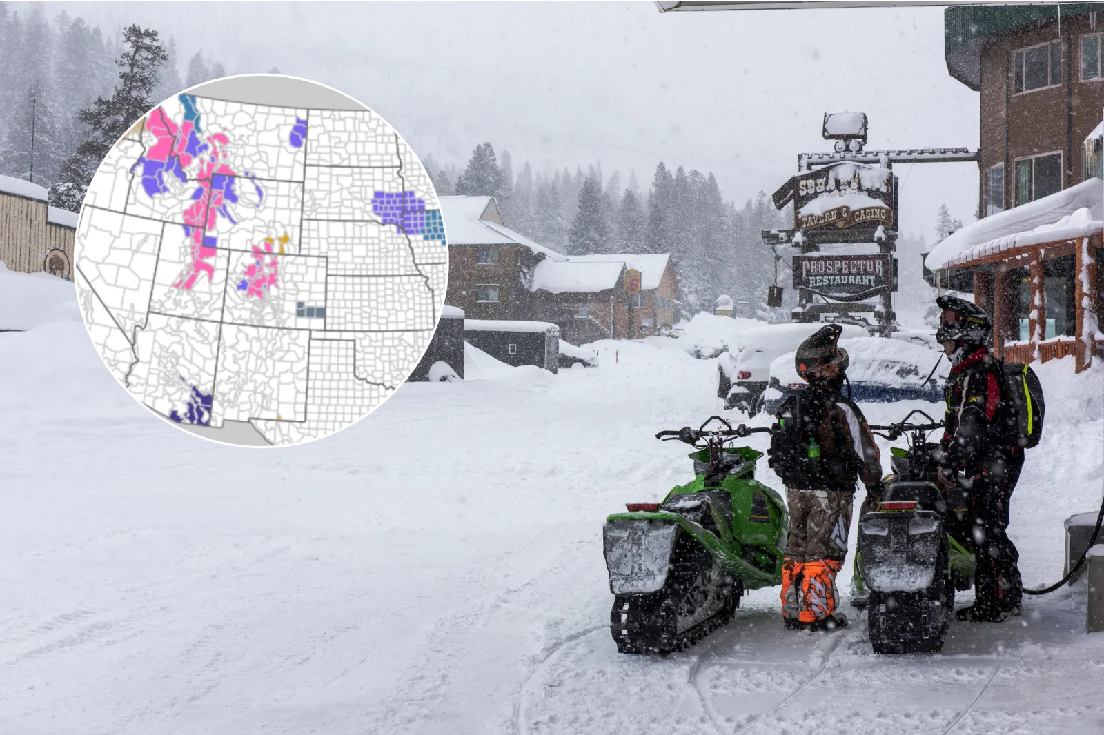
Thousands of people across seven U.S. states are bracing for a powerful winter storm, with the National Weather Service (NWS) warning that some locations could see up to three feet of snow.
A mix of winter storm warnings and watches, winter weather advisories, and blizzard warnings is in effect across a broad swath of the country, stretching from the Mountain West all the way to Alaska.
Forecasters say hazardous conditions in higher elevations may severely affect travel, strain power systems, and threaten public safety. In several regions, the NWS cautions that travel could become “very difficult to impossible,” and that some outdoor activities may quickly turn “life-threatening.”
What Do the Warnings Mean?
The NWS issues a winter storm warning when there is high confidence that heavy snow, sleet, or freezing rain will create “significant impacts.” A winter storm watch is issued when there is medium confidence that such severe conditions could develop.
A winter weather advisory is used when lighter wintry precipitation or areas of blowing snow are expected to cause slick, hazardous conditions that can make travel difficult, particularly if people do not take proper precautions.
An NWS blizzard warning is issued when, within the next 12 to 18 hours, snow and/or blowing snow is expected to reduce visibility to 1/4 mile or less for at least three hours, alongside sustained winds of 35 mph or stronger, or frequent gusts at or above 35 mph.
Winter Storm Warnings
Winter storm warnings have been posted for parts of Colorado, Utah, Alaska, Idaho, Montana, Washington, and Wyoming.
Mountain passes such as Cottonwood Pass, Rabbit Ears Pass, Teton, Togwotee, and Salt River Passes could receive anywhere from one foot to as much as three feet of snow in isolated spots. Strong winds up to 65 mph may further reduce visibility and create near-whiteout conditions.
Colorado
Central Mountains (Aspen, Vail, Leadville areas):
Snow totals of 6–12 inches are expected under a winter storm warning from 11 p.m. MST Friday through 11 p.m. MST Saturday. Winds of 35–65 mph are forecast over passes such as Vail Pass and Monarch Pass, where roads may become snowpacked with poor visibility. Travel will be very difficult. The NWS urges people to avoid mountain travel during the storm or use extreme caution, including tire chains and winter emergency kits if driving is unavoidable.
Northern Mountains (Rocky Mountain National Park, Summit County):
Forecasters call for 7–14 inches of snow from 11 p.m. MST Friday through 11 p.m. MST Saturday. Gusts up to 55 mph are likely, with blowing snow expected to impact routes like Trail Ridge Road and I-70, which may close or become impassable. The NWS strongly recommends adjusting travel plans for Friday night through Saturday. Anyone who must travel should be prepared for road closures and carry an emergency kit.
Northwest Colorado (Rabbit Ears Pass, Flat Tops):
Up to 20 inches of snow is possible under a winter storm warning from 11 p.m. MST Thursday through 11 p.m. MST Saturday. Gusts of 45–55 mph and near-blizzard conditions may develop Friday night into Saturday, making Rabbit Ears Pass extremely dangerous or impassable. The NWS advises delaying or avoiding travel in this area; if driving is essential, motorists should use chains and carry a full winter survival kit.
Idaho
Southeast Mountains (SE Idaho):
Mountain areas could see 10–18 inches of snow, with a winter storm warning in effect from Thursday evening through 5 a.m. MST Saturday. Some roads may become impassable. The NWS recommends avoiding mountain travel during the height of the storm and warns that those who must travel should expect delays and bring emergency supplies.
Northern Panhandle (Idaho/Montana border):
Up to 12 inches of snow is forecast under a winter storm warning from Thursday through 4 p.m. PST Saturday. Roads are likely to be snow-covered and slick. The NWS urges drivers to anticipate winter driving conditions, check pass reports, and prepare for potential travel disruptions.
Alaska
Skagway & Klondike Highway (Alaska Panhandle):
As much as 26 inches of snow is expected, with a winter storm warning in effect from 10 p.m. Friday to 3 p.m. Sunday AKST. Gusts up to 45 mph may down tree branches and further complicate travel. The NWS advises avoiding nonessential travel and recommends that anyone who must drive carry emergency supplies.
Haines & Haines Highway (Alaska Panhandle):
Up to 19 inches of snow is forecast under a winter storm warning from 3 a.m. Saturday through 3 p.m. Sunday AKST. Wind gusts up to 45 mph could cause tree damage and hazardous conditions. Officials suggest postponing travel if possible and ensuring that both property and vehicles are prepared if travel cannot be avoided.
Montana
Central & Southwest Mountains:
Up to 15 inches of snow is expected, with a winter storm warning in place through Saturday afternoon MST. Significant accumulations are likely in ranges such as the Little and Big Belt, Bridger, Madison, and Beaverhead Mountains. Passes including Bozeman Pass, Kings Hill, and Chief Joseph Pass will likely be snowpacked, and chains or four-wheel drive may be necessary.
Western Montana (Bitterroot and Seeley/Swan areas):
Snow totals up to 15 inches are forecast, with a warning valid until Saturday afternoon MST. Steady snow is expected in valleys and heavier snow over passes like Lolo Pass, Lost Trail Pass, and Lookout Pass. Travel along US-93, I-90, and nearby corridors will be challenging. The NWS urges caution on mountain roads and suggests postponing trips until conditions improve.
South-Central Mountains:
Up to 24 inches of snow is possible through 2 p.m. MST Saturday. Heavy snowfall is expected across the Absaroka, Beartooth, and Crazy Mountains. Backcountry conditions will be dangerous, with potential whiteouts. The NWS advises anyone heading into the backcountry to be prepared for deep snow and potentially life-threatening winter conditions.
Utah
Wasatch Mountains (Northern Utah):
Between 1 and 3 feet of snow is forecast under a winter storm warning that remains in effect until 5 a.m. MST Sunday. Major snowfall is anticipated across the Wasatch Range, including the Cottonwood Canyons and Bear River Range. Mountain roads may become extremely difficult or close entirely, and traction restrictions are likely.
Uinta & Central Mountains:
Up to 2 feet of snow is predicted, with a winter storm warning active until 5 a.m. MST Sunday. Heavy snow is expected in the western Uinta Mountains and the Wasatch Plateau/Book Cliffs. Routes such as Soldier Summit will be snowpacked and hazardous. The NWS warns of long delays and possible closures on mountain passes. Drivers who must travel should carry an emergency kit and prepare for severe winter conditions.
Wasatch Back Valleys:
Snow totals up to 16 inches are possible, with a winter storm warning in effect until 5 a.m. MST Sunday. High valleys, including Park City and Heber City, are likely to see significant accumulation, and even lower valley floors could pick up 2–6 inches. Snow is expected to affect both the Friday morning and evening commutes.
Wyoming
Southern Wyoming (Snowy & Sierra Madre Ranges):
A winter storm warning is in effect from 11 p.m. MST Thursday through 5 a.m. MST Sunday, with 1–2 feet of snow forecast. Blizzard-like conditions are expected in the southern mountain ranges. The NWS warns that frostbite and hypothermia can develop quickly and that outdoor recreation could be life-threatening without proper preparation.
Northwest Wyoming (Teton & Salt River Ranges):
A winter storm warning remains in place until 2 p.m. MST Saturday, with up to 20 inches of snow and gusts up to 45 mph expected. Very heavy snow is forecast across the Teton, Gros Ventre, and Wyoming Ranges. Passes such as Teton Pass and Togwotee Pass will be snowpacked with poor visibility. Travel across these routes on Friday and Saturday is strongly discouraged. Those who must drive should expect closures and carry chains, warm clothing, and emergency supplies.
Winter Storm Watches
Winter storm watches cover parts of Alaska and Montana, signaling the potential for heavy snow, strong winds, and increasingly dangerous travel.
In Alaska, areas including the Kuskokwim Delta Coast, Nunivak Island, and Yakutat could experience blizzard conditions and substantial snowfall beginning Saturday. Visibility may drop to near zero, with wind gusts up to 60 mph.
Northern sections of Montana, including the Continental Divide and Glacier Park region, are preparing for up to 25 inches of snow and gusty winds, which could severely disrupt travel through mountain passes.
Winter Weather Advisories
Winter weather advisories stretch from the Pacific Northwest to portions of the Mid-Atlantic and Southeast.
These advisories highlight lighter, but still disruptive, snow accumulations—generally 1 to 6 inches—along with pockets of freezing rain and gusty winds.
States such as Colorado, Idaho, Utah, Kentucky, Virginia, and North Carolina are dealing with slick roads, reduced visibility, and hazardous commuting conditions. Even areas that receive only minimal snow may see icy surfaces, prompting officials to urge caution and suggest delaying nonessential travel when possible.
Blizzard Warnings
Blizzard warnings are focused on interior Alaska, particularly along the Dalton Highway and in the Eastern Alaska Range.
These regions are expected to face prolonged periods of blowing snow, extreme wind chills that could fall to -60°F, and near-whiteout conditions from Friday night into early next week. The combination of strong winds and bitter cold poses serious risks to travelers and outdoor workers. Authorities recommend restricting travel to emergencies only and stress the importance of carrying winter survival gear for anyone who must be on the roads.